Date:
March 13, 2006
From: Steve Hilberg
Subject: ARES of Champaign County QST - March 2006
This is
a special edition of the monthly newsletter. There was not a
regular March meeting due to NWS Storm Spotter Training being offered
on the same night as our regular meeting.
NWS
SPOTTER TRAINING
The
following ARES members attended the March 1 session. If your
call sign is not on this list and you attended, please let me
know. Also, if you attend NWS training at another location,
be sure to let me know when and where so I can make a note of that on
your training record. For
specific dates, times, and locations check the NWS Lincoln web site at
the following link: http://www.crh.noaa.gov/ilx/spotter2.php
.
N9GPA
KB9KAI
AB9FJ
KB9LCJ
KB9VFZ
KC9DSS
K9MLT
K9SI
KC9DEQ
KC9IKL
KB9ZZQ
WB9HFK
W9MOO
KC9HND
W9ADS
KB9NBH
KD5EOQ
KC9IHX
N9XDH
In addition, all CCARES
spotters must attend our "Spotter Preparation, Safety, and
Communications" training which will be offered at our April 5
meeting. While the NWS training covers more on what to spot,
our training covers how to spot, including a review
of our severe weather net procedures.
GREAT RESPONSE FOR FIRST SEVERE WEATHER ACTIVATION
The first severe weather of the season occurred on Sunday,
March 12, when most of Illinois was in a Moderate Risk for severe
weather and central and northwestern Illinois were in a High
risk. A tornado watch was issued about noon for much of
Missouri and the western half of Illinois for a 10 hour
period. The size and duration of the watch area was
indicative of the potential seriousness of the situation. A
number of supercell thunderstorms developed over Missouri and crossed
the river into Illinois. The approach of one of the
cells to Springfield prompted activation of the Champaign County severe
weather net. This storm originated in southeastern Kansas and
persisted over an incredibly long 10+ hours and 500+ miles.
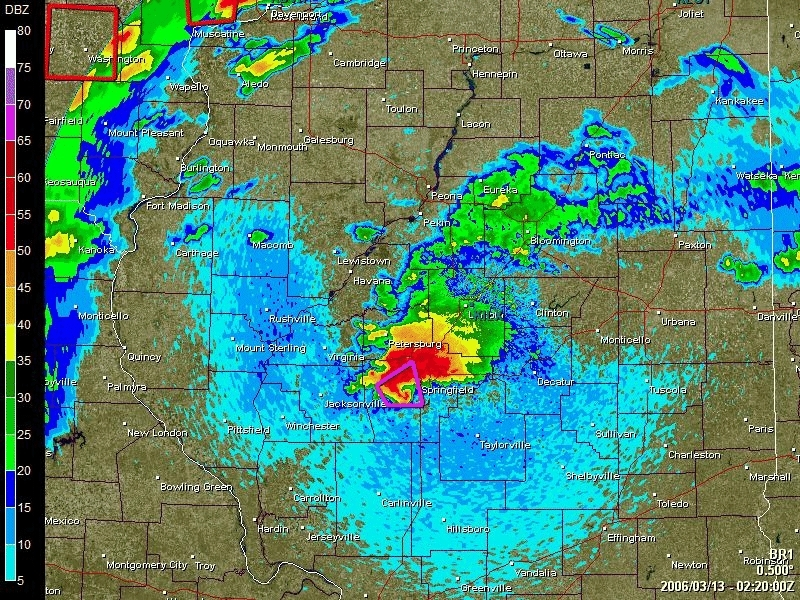
The storm struck the Springfield area between 8:00 and 8:30
p.m. Here is a radar image of the storm at 8:20 p.m. CST
showing a characteristic "hook echo" near Springfield. The
violet polygon is the tornado warning area.
We had 13 spotters check in to the net. We ended up
dispatching 4 teams of two spotters to cover the expected track of this
storm. Many thanks to those who checked-in and remained on
standby during this event. In most severe weather cases we would be
dispatching additional spotters especially when there are numerous
storms. However, the singular nature of this storm did not
require any more teams in the field. Thanks to Dave
Leininger, W9DML, for running a Resource Net while I was en route to
the EOC.
A threat for severe weather remained high even after this storm moved
off to the northeast into Indiana. The net went on standby
until it was clear what the next round of storms would do. A
number of ARES members agreed to standby into the early morning hours
in case spotters were needed again. A second supercell
prompted additional tornado warnings for the Springfield area around
1:00 a.m. , but that storm died soon after moving into eastern Sangamon
County. Fortunately, the conditions favorable for tornadic
storms became less favorable as the last line of storms moved into
Illinois. I closed out the ARES standby about 3:00
a.m. when it appeared the last line of storms were weakening and headed
for home.
Thanks again to everyone who checked in Sunday night.
MARCH
NET CONTROL STATIONS
The
weekly ARES net is held each Tuesday, 9:00 p.m., on the 444.100
repeater, CTSS 162.2. An updated net check-in list is now
available on the web site.
March
7 K9MLT
March
14 KC9DSS
March
21 N9GPA
March
28 N9XDC
April
4 W9ADS
NEXT
MEETING
The
next regular meeting will be on Wednesday, April 5th, 7:00 p.m. at the
Fire Service Institute where the training topic will be "Spotter
Preparation, Safety, and Communications" and review of our Severe
Weather Net procedures.